Dinosaur Tracks and Wind Caves at Thompson Springs Trail
Crescent Junction on I-70 east of Green River is the place to turn south to Moab. Just three miles east is the sleepy little town of Thompson Springs — a place to stage a great ATV adventure.
Gathering at the Ballard RV Park, the NUATV club lined up and headed south under the freeway. Our parade of 28 machines carried more people than the population of the town.
That number dropped to 27 when one caught fire and had to be left behind. It seems that an adjustment made before we started caused a partial application of the brakes. The friction caused the fire.
Traveling south on the Salt Valley Gorge Road, we were enjoying perfect riding weather. The sun was bright and a light jacket was all we needed on this late April ride.
We were riding on a low ridge east of Thompson Wash. This is rugged country with a wild feel to it. The trail was not difficult, but vegetation was sparse. Our track took us along the northeast border of Arches National Park.
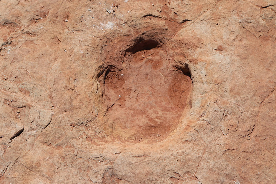
Stopping at Yellow Cat Wash, we took a short hike southwest in the wash. Where the water had cleared the dirt away, we saw dinosaur tracks of many sizes permanently pressed into the rock. It was fun to look for them in the wash.
Some tracks were the size of hubcaps — oops, that dated me. They were more like the size of a laptop computer.
Crossing Yellow Cat Flat, we passed Dry Oak Spring and turned south. Mining played a part of the history of this area, as we passed several claims. I love the names of some of these old mines — Little Eva, Ringtail, Cactus Rat and Poison Strip.
Passing the Highlands, we came onto Owl Draw. Traveling east, we then looped back to the west and stopped for lunch at a place called the Wind Caves.
This was a fascinating place to stop. We were in a huge stone grotto. The walls featured caves — some connected and some didn’t.
I walked into one that I illuminated with the flash of my camera. The sandy floors were inviting and it would be a cool respite on a hot day. However, I am not sure I would like to seek refuge here and find that some wild critter had the same idea.
I am told that there is one of these caves with a small opening. If you can squeeze through, it expands into a large cavern some 20 feet high. I wasn’t ready to try that one. This place would be fun to come back and spend some time exploring.
We made one more stop at a place called “The Arch.” I guess I would expect an arch in this country, being close to the national park. I just would have expected a little more creativity in naming it.
Our last stop was at an overlook of the Colorado River. The view here was amazing. The river was some 1,600 feet below us and we could see Highway 128 that follows the river east from a junction in Moab.
This view was special because I could see trails that I have ridden before across the valley. The Onion Creek Trail snaked away east as it disappeared up the canyon. I could also see Fisher Towers below the end point of the Top of the World Trail. I couldn’t see Moab, but I knew it was behind the ridge that featured Castle Rock.
Heading back, we crossed Cottonwood Wash and passed by Yellow Cat Mesa. We came back to I-70 where we took an overpass and turned onto the Old Cisco Highway back to Thompson Springs.
Following the Denver and Rio Grande Railway, I noticed some white flowers between the road and the tracks. I realized that they were sego lilies. I remembered seeing them last year on the Tusher Canyon Trail about the same time of year. It is always a treat to find a sego lily because I rarely find them when and where I expect them.
When you go take plenty of water, keep the rubber side down and enjoy some wild country in Grand County.
Source: www.standard.net